White Memorial - Mattatuck Trail - Litchfield, CT
White Memorial – Mattatuck Trail: A Top Dog-Friendly Trail in Litchfield, Connecticut
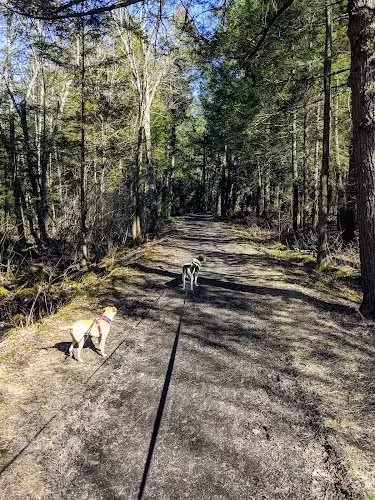
Located in scenic Litchfield, CT, the White Memorial – Mattatuck Trail is a haven for dog owners seeking adventure and quality time with their pets. Spanning 4,000 acres and boasting over 40 miles of dog-friendly hiking trails, this expansive preserve offers picturesque forest views, tranquil wetlands, and multiple ponds, making it one of the top spots for pet-friendly trails in Connecticut. Dogs are welcome on the trails, and the gentle paths are perfect for walking, jogging, or hiking with your furry companion. The area is also popular for birdwatching, wildlife viewing, and family outings, thanks to its easy to moderate loops and beautiful scenery year-round.
Amenities include a wheelchair-accessible parking lot, several small parking areas near trailheads, and a relaxed, family-friendly environment. While there isn’t a designated off-leash dog park area, leashed dogs can enjoy the many interconnected trails and natural features like beaver ponds and blooming mountain laurels. Remember to bring a trail map, as the vast network of paths can be a delightful maze for explorers and their pups. Whether you’re searching for dog-friendly hiking in Litchfield County or a picturesque place to spend a weekend, White Memorial – Mattatuck Trail is a must-visit destination for both people and pets.
Frequently Asked Questions
- Are dogs allowed at this park? Yes, dogs are allowed on the trails.
- Is the park wheelchair accessible? Yes, there is wheelchair-accessible parking.
- Is there a playground or activities for kids nearby? Yes, the park is good for kids and features kid-friendly hikes.
- Where is the best place to park? There are several small parking areas at different trailheads, including wheelchair-accessible lots.
- Are there walking or hiking trails connected to the park? Yes, the park features over 40 miles of interconnected hiking trails.
- Is the park open year-round? Yes, the trails are open and accessible throughout the year.
- How busy does the park get on weekends? Even when popular, the vast acreage means the trails rarely feel crowded.
Reviews
40 miles of trails and 4000 acres of forest and wetlands. Lots of picturesque scenery. These trails are beautiful. Bantam Lake and Bantam River ate both accessible by White Memorials Point Folly Marina and boat launch at 123 North Shore Rd in Litchfield. #hiking #biking #habitat #snowshoeing #nature #fishing #camping #wildlife #horsebackingriding #bridletrail #museum #bantam #litchfieldcounty
This trail is easy . About 2 .Ile loop arou.d the ponds. Gravel path most of the way. Small parking lot.
Great trail around amazing beaver ponds on a mild and bit rainy morning – the fog over the marshes and ponds was magical! So much green for December – small stands of soft pines, large groups of mountain laurel that must be beautiful in bloom. Bring the trail map as I did get off course and had to walk on a dirt road then Rte 63 before heading back into the forest.
This is a beautiful trail system. My friend and I hiked the beaver trail segment past Teal pond. We started at the trail head on 63 at the intersection of 61. There is a strip of parking on the edge of the road for about 5 or 6 cars depending on how well cars are parked. The trail was covered in snow mostly but had been packed down for x country skiers so very walkable. I recommend taking a snapshot of the trail map so you can orient yourself with all the intersecting trails. We forgot so retraced our steps to go back to the car. A map would have made it easy to make the hike into a loop. Families with young children, dogs, couples and seniors were out enjoying the trails. Even so it didn’t feel crowded. Gentle hills and beautiful scenery made this an easy to moderate hike/walk. Fun to see evidence of beavers heard at work. 🦫
There are so many different trails to explore here, and you can travel to 7 different ponds throughout the hiking system! The land is so expansive that in the 6 years I’ve been hiking here I still haven’t seen everything. You definitely need to look at the map so you can plan out your hike and explore the path less travelled.