Orkney Springs Trail - Basye, VA
Orkney Springs Trail – Dog-Friendly Hiking in Basye, VA
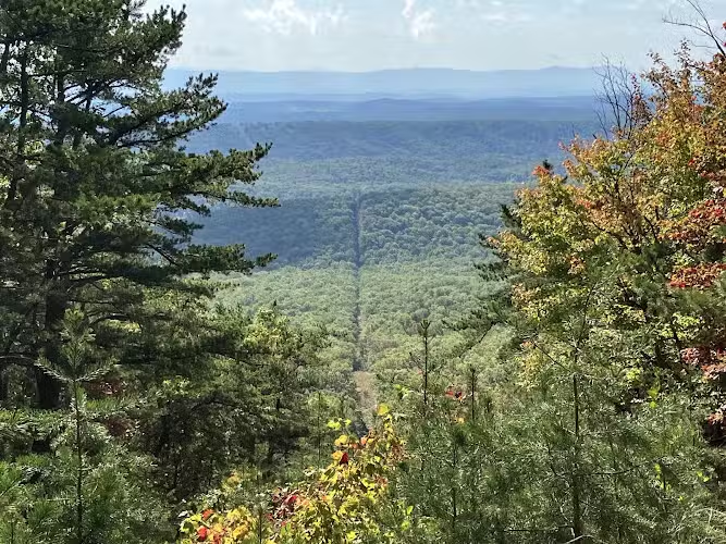
Discover the natural beauty of Orkney Springs Trail, a premier dog-friendly hiking destination nestled in the scenic Shenandoah foothills near Basye, VA. This out-and-back trail welcomes leashed pets and is perfect for active dog owners seeking pet-friendly trails in the area. The well-marked path spans approximately 1.8 miles each way, featuring a moderate incline with rocky stretches, gentle creek crossings, and rewarding mountain views. For those seeking a peaceful escape, the trail is often quiet and lightly trafficked, especially on weekdays.
Families and outdoor enthusiasts will appreciate the trail’s natural setting, with multiple stream crossings and forested paths that offer shade and beautiful vistas. While there are no fenced off-leash dog areas or specific dog amenities like water stations or agility equipment, Orkney Springs Trail stands out for its scenic environment and welcoming attitude toward leashed pets. Whether you’re looking for a fun hike with your pup or a tranquil walk surrounded by nature, this Basye, VA dog park alternative provides a memorable outing for both you and your furry friend.
FAQ
- Are dogs allowed at Orkney Springs Trail? Yes, dogs are welcome on this trail.
- What are the leash requirements? Dogs must be kept on a leash while hiking.
- Is the trail wheelchair accessible? No, the trail does not have wheelchair accessible entrances.
- Is the trail good for kids? Yes, the trail is considered good for kids and is kid-friendly.
- Are there walking or hiking trails connected to the park? Yes, Orkney Springs Trail itself is a hiking trail and offers an out-and-back route suitable for walking and hiking with dogs.
- Is there shade available? Yes, much of the trail is shaded by natural tree cover.
Reviews
Very rocky trail, moderate difficulty. Aboit 1 mile in there is pretty little creek crossing.
A really good hike. My Garmin had it about 1.8 miles out. A little steeper and more rocky than my wife would liked after the first mile, but we both pushed through for the view. Would recommend.
All up a loose Rocking mountain! Cross over 3 springs (beautiful). No need to hike the last 1/2 mile – no scenery. I would rate this moderate to hard because of the steep hill full of loose rocks
It is a beautiful easy-to-moderate hike. It is in fact mainly easy, the moderate part is just for some incline as you get higher. You’ll cross the creek 3 times going up. Beautiful views. At this time of the year (March) we haven’t encountered anyone while hiking. And no cars were parking in at the start. Totally recommend it!
Well worn and marked trail. Easy to follow. It took us about 65 minutes to walk to the “oil pipe” where you get a great east looking view at the Shenandoah mountains in the distance. ~First half of the hike is dirt and rocks, easy to moderate. Second half is rocky most of the way and moderate. Very fun trail! It was empty on the Tuesday morning we hiked. As mentioned by others, 3 very small streams to cross. There were 2 downed trees across the trail. Not to hard to get over or go around. It took about 55 minutes to come down. We took our time going up and down.