Roaring Kill Trail - Elka Park, NY
Roaring Kill Trail – Dog-Friendly Hiking in Elka Park, New York
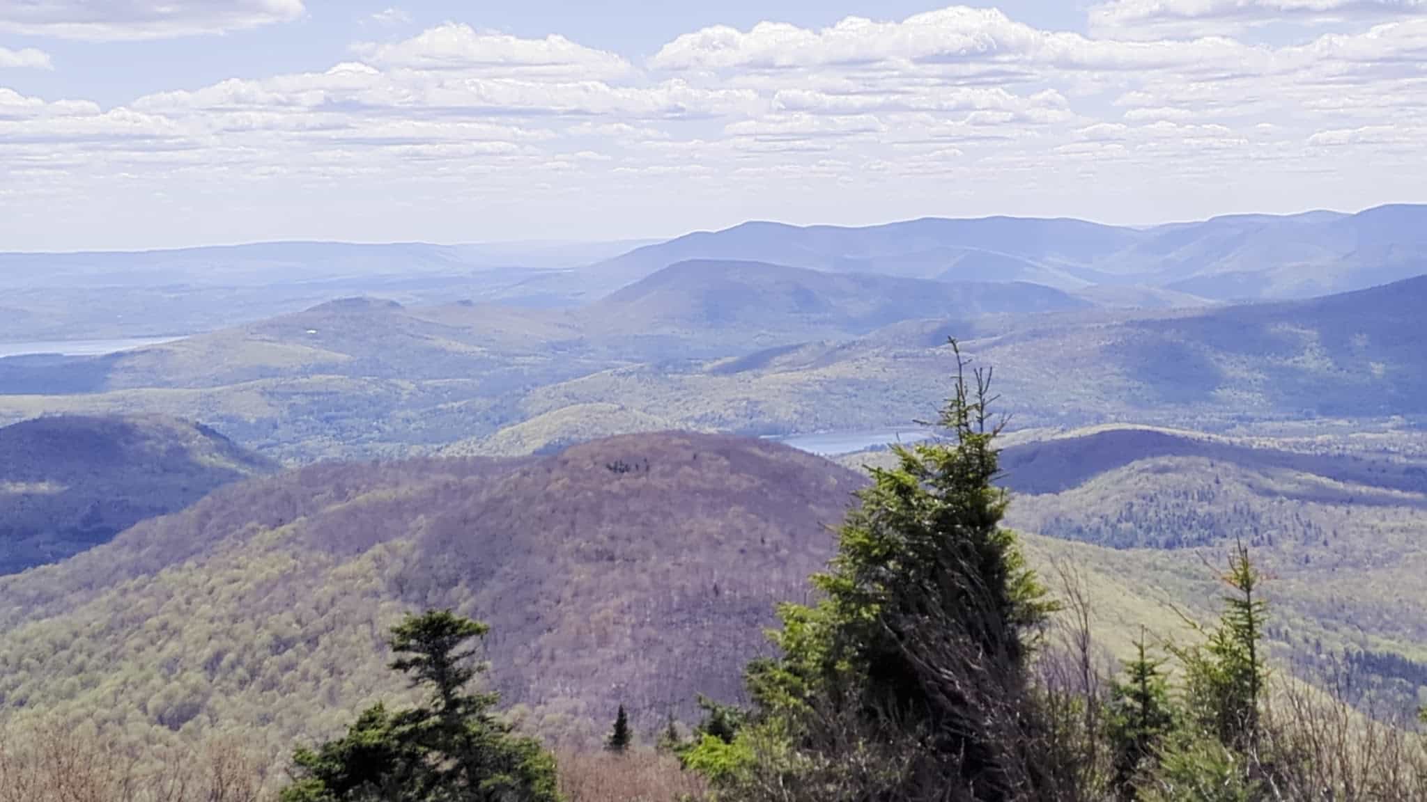
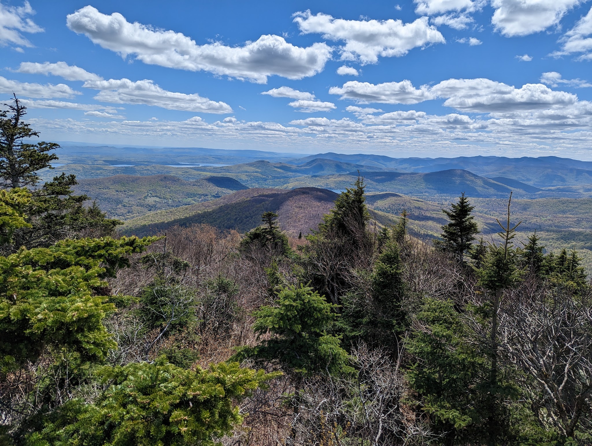
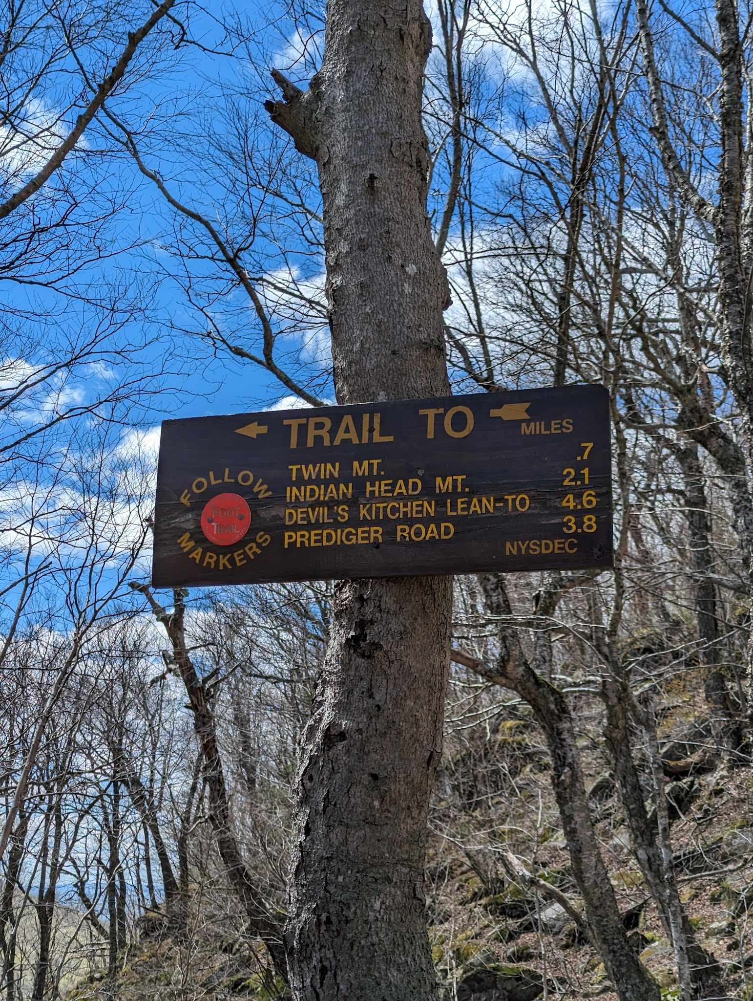
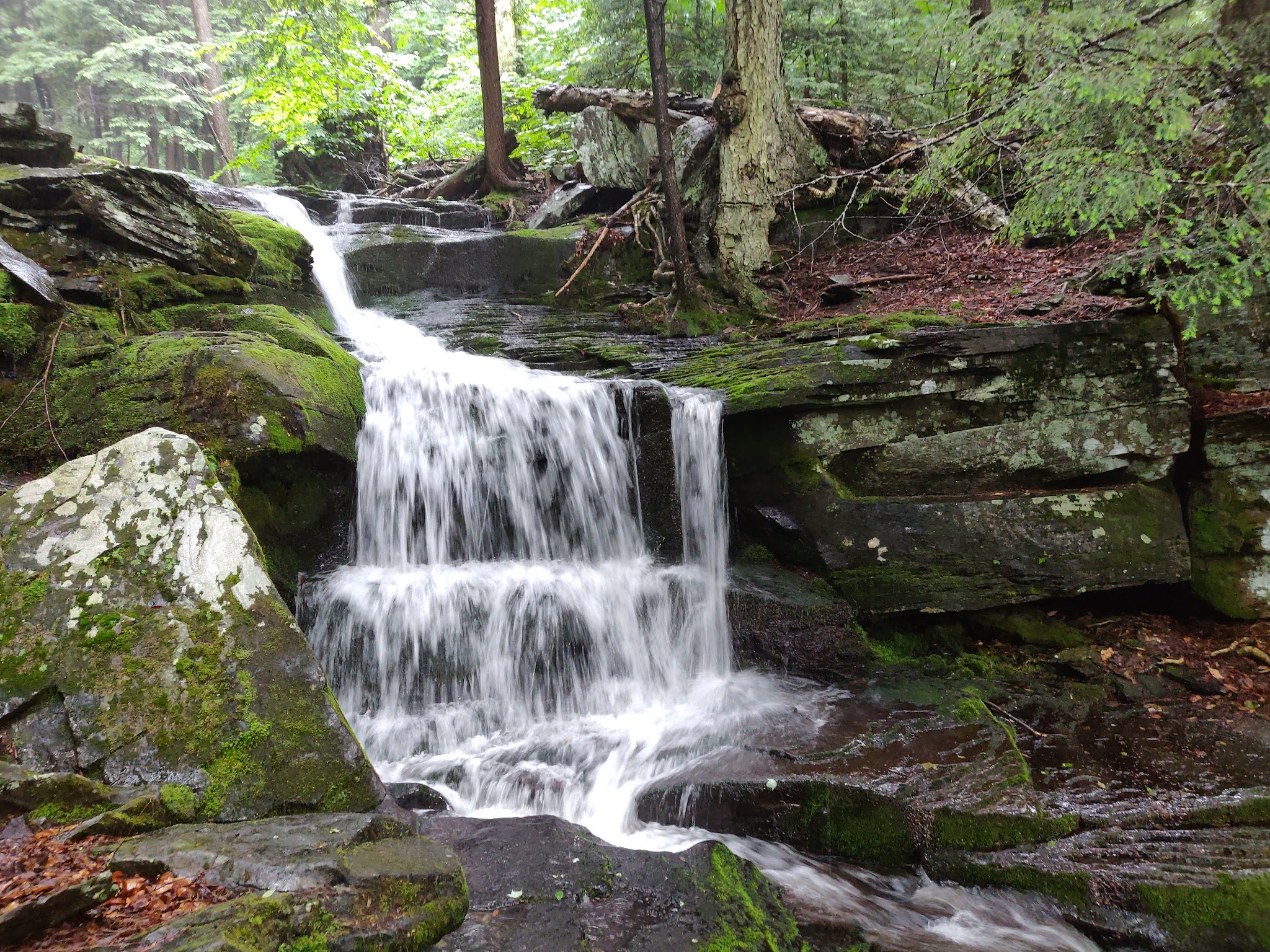
Located in the scenic Catskills, Roaring Kill Trail is a great spot for those seeking dog-friendly hiking near Elka Park, NY. This short 0.2-mile connector provides convenient access to longer, more challenging trails such as Mink Hollow and Pecoy Notch, leading to iconic destinations like Sugarloaf and Twin Mountain. Enjoy pet-friendly wilderness full of lush forests, rocky scrambles, and stunning views—perfect for experienced hikers and their four-legged companions who love adventure.
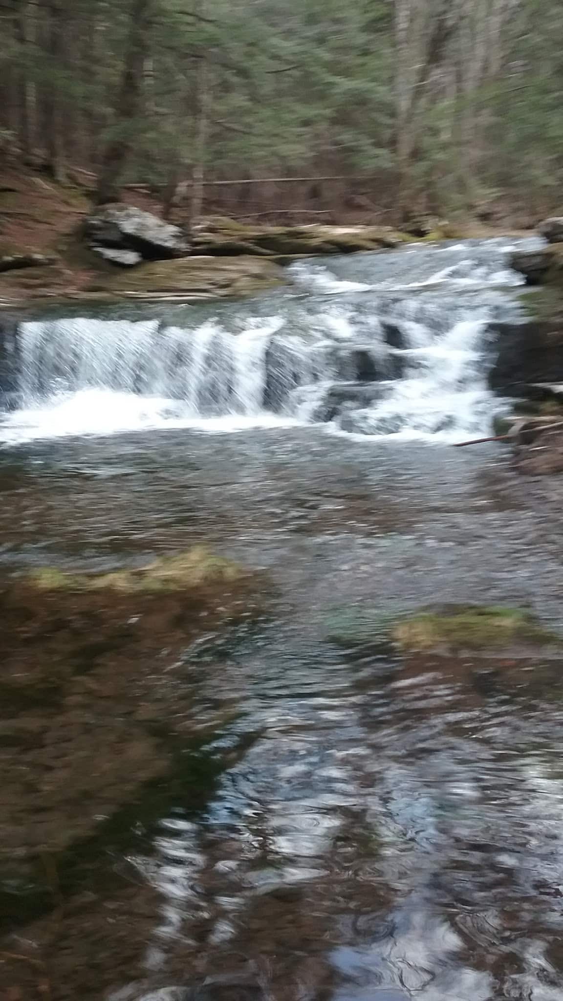
The trailhead features a parking area (fits about 10–20 cars), making it one of the more convenient access points to the famed Devil’s Path. While there’s no fenced dog park or separation for small and large dogs, the trails offer plenty of natural exploration for well-conditioned, adventurous pets. Please note: many trails in this area are rated as hard, with wet, muddy, or slippery sections—dogs should be able to handle tough terrain, and caution is advised during rain or wet seasons. There is partial shade from the dense forest canopy and beautiful wild scenery to enjoy year-round.
Roaring Kill Trail FAQ
- Are there walking or hiking trails connected to the park? Yes, Roaring Kill Trail connects to Mink Hollow Trail and Pecoy Notch Trail, which lead to Devil’s Path, Sugarloaf Mountain, and Twin Mountain.
- Where is the best place to park? There is a dedicated parking area at the Roaring Kill trailhead, suitable for about 10–20 cars.
- Is the park muddy after it rains? Yes, the trails are reported to be very muddy and wet after it rains. Extra caution is recommended.
- Is there shade or shelter available? Yes, much of the trail is shaded under the forest canopy, though no man-made shelters are present.
- Are there leash requirements? Dogs may be allowed, but owners are advised to keep them leashed especially on rugged, popular, or challenging sections for safety.
- Are there restrooms available for owners? No information is available about restroom facilities at the trailhead.
Reviews
This review is for Sugarloaf Mountain Loop via Pecoy Notch Trail. This is a really hard trial. Some people write as if it’s moderate or no big deal. I’m quite fit – even if not the fittest athlete in the world, I’m in great shape and have high endurance capability. This is not an easy or moderate trial. Also, the distance isn’t correct – the loop ended up being about 7.8 miles and not the posted 6.3 miles. It has very rough terrain start to end with endless rocks and roots grinding your feet and ankles. Don’t get me wrong – it’s an amazing trail, just don’t let yourself think it’s a walk in a park. Somewhere midway it starts to have those fun scrambles all over as you ascend. Few tricky spots but nothing too crazy. But be prepared that the rocks as of now are extremely slippery and and it’s easy to lose grip. I fell twice or thrice. It especially matters when you need to choose your route when scrambling. A few spots seemed safer to bushwhack around a bit rather than slipping and breaking a bone or two. Not too many views. There’s a lookout on the top but mostly that’s it. The making is there but not the best in the world. Distances between markers can be long and sometimes it’s confusing. I had to be glued to the map and NAV as I noticed I got off trail quite a few times although luckily I figured that very quickly every time. The forest is majestic and completely wild. It’s an amazing experience. I ended up finishing last two miles in complete darkness with my headlamp. It’s even trickier to follow the markings in the dark, of course. Much recommend this but not to beginners. Cheers!
This review is for Sugarloaf Mountain Loop via Pecoy Notch Trail. This is a really hard trial. Some people write as if it’s moderate or no big deal. I’m quite fit – even if not the fittest athlete in the world, I’m in great shape and have high endurance capability. This is not an easy or moderate trial. Also, the distance isn’t correct – the loop ended up being about 7.8 miles and not the posted 6.3 miles. It has very rough terrain start to end with endless rocks and roots grinding your feet and ankles. Don’t get me wrong – it’s an amazing trail, just don’t let yourself think it’s a walk in a park. Somewhere midway it starts to have those fun scrambles all over as you ascend. Few tricky spots but nothing too crazy. But be prepared that the rocks as of now are extremely slippery and and it’s easy to lose grip. I fell twice or thrice. It especially matters when you need to choose your route when scrambling. A few spots seemed safer to bushwhack around a bit rather than slipping and breaking a bone or two. Not too many views. There’s a lookout on the top but mostly that’s it. The making is there but not the best in the world. Distances between markers can be long and sometimes it’s confusing. I had to be glued to the map and NAV as I noticed I got off trail quite a few times although luckily I figured that very quickly every time. The forest is majestic and completely wild. It’s an amazing experience. I ended up finishing last two miles in complete darkness with my headlamp. It’s even trickier to follow the markings in the dark, of course. Much recommend this but not to beginners. Cheers!
This review is for Sugarloaf Mountain Loop via Pecoy Notch Trail. This is a really hard trial. Some people write as if it’s moderate or no big deal. I’m quite fit – even if not the fittest athlete in the world, I’m in great shape and have high endurance capability. This is not an easy or moderate trial. Also, the distance isn’t correct – the loop ended up being about 7.8 miles and not the posted 6.3 miles. It has very rough terrain start to end with endless rocks and roots grinding your feet and ankles. Don’t get me wrong – it’s an amazing trail, just don’t let yourself think it’s a walk in a park. Somewhere midway it starts to have those fun scrambles all over as you ascend. Few tricky spots but nothing too crazy. But be prepared that the rocks as of now are extremely slippery and and it’s easy to lose grip. I fell twice or thrice. It especially matters when you need to choose your route when scrambling. A few spots seemed safer to bushwhack around a bit rather than slipping and breaking a bone or two. Not too many views. There’s a lookout on the top but mostly that’s it. The making is there but not the best in the world. Distances between markers can be long and sometimes it’s confusing. I had to be glued to the map and NAV as I noticed I got off trail quite a few times although luckily I figured that very quickly every time. The forest is majestic and completely wild. It’s an amazing experience. I ended up finishing last two miles in complete darkness with my headlamp. It’s even trickier to follow the markings in the dark, of course. Much recommend this but not to beginners. Cheers!
Wonderful hike up to Twin Mountain. Prepare yourself for the last 3/4 miles to the summit however, as the rock scramble should be considered intense for the fair weather hiker. Pay attention to weather conditions as well, we did the scramble in the rain, which I would not recommend unless you are experienced/prepared. If you don’t feel like going that far, the hike to the quarry is worth it by itself and is definitely a treat. The fen is also a beautiful sight.
Wonderful hike up to Twin Mountain. Prepare yourself for the last 3/4 miles to the summit however, as the rock scramble should be considered intense for the fair weather hiker. Pay attention to weather conditions as well, we did the scramble in the rain, which I would not recommend unless you are experienced/prepared. If you don’t feel like going that far, the hike to the quarry is worth it by itself and is definitely a treat. The fen is also a beautiful sight.
Wonderful hike up to Twin Mountain. Prepare yourself for the last 3/4 miles to the summit however, as the rock scramble should be considered intense for the fair weather hiker. Pay attention to weather conditions as well, we did the scramble in the rain, which I would not recommend unless you are experienced/prepared. If you don’t feel like going that far, the hike to the quarry is worth it by itself and is definitely a treat. The fen is also a beautiful sight.
Roaring Kill trail is a 0.2 mile connector between Roaring Kill trailhead parking (about 10-20 cars) and Mink Hollow Trail and Pecoy Notch trail.
Mink Hollow Trail traverse the slope of Sugarloaf from the west and intersects with the Devil’s path between Sugarloaf and Plateau mountains. Pecoy Notch trail does the same from the east and connects to the Devil’s path between Twin and Sugarloaf mountain. This trail and the trailhead is one of the convenient access/bailout points for the Devil’s path. As this trail is short I included pictures for both Mink Hollow trail and Pecoy Notch trail. Both these trail are pretty shallow and easy.
This trail leads to the Devil’s Path. Trail is very muddy and very wet right now. There’s a fair amount of parking and the road to it is in decent shape.
I took Pecoy’s Notch from it to the top of Twin mountain. Pecoy’s Notch is no joke. That’s a hard trail. Those looking to get Twin knocked off their list and figure this is the most direct and fastest route beware. If you’re not conditioned you’re gonna have a hard time. From the time you get off roaring kill trail and meet Pecoy’s Notch there’s lots of scrambles and many times I needed to use my hands.
I did manage to get the dog through it because she’s a real trooper. But if your dog is older or clumsy I would not advise bringing the dog.